The Hague worst hit in the case of extreme precipitation
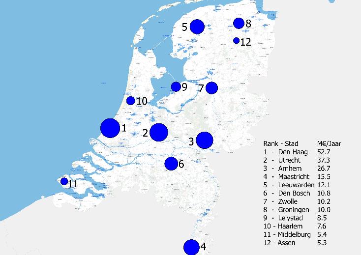
TU Delft and consultancy firm HKV have developed a precipitation index in order to compare the risks that different cities face from extreme precipitation. The method has been applied to the Dutch provincial capitals. The Hague is revealed as being the most affected.
Heavy rainfall is increasingly causing flooding in urban areas. If excess rainwater does not drain away through sewers, ditches and canals rapidly enough, it causes pluvial (surface water) flooding. As urbanisation continues, an increasing percentage of the ground's surface is paved. However, if measures are taken, the chances of these floods and their consequences can be reduced.
Benchmark
Under the supervision of Dr. Bas Kolen (TU Delft and consultancy firm HKV) and Dr. Saskia van Vuren (TU Delft and Dutch national public works agency Rijkswaterstaat), Bachelor's student Tjerk Krijger therefore developed a method to determine the risks of extreme precipitation, interpret these risks and compare cities with each other. Because it is based completely on open data and quantitative analysis, this method is reproducible, enabling cities to be effectively compared with each other.
It uses the latest precipitation statistics and models in order to determine the amount of water on ground level during peak rainfall. The method has been applied to the Dutch provincial capitals. Alongside the risk, various other parameters have been quantified to interpret the risk and define ambitions, such as the number of objects that can be affected, the number of inhabitants and the number of reports.
Increasing risk
The risk was calculated for each city and the cities were then ranked based on this risk. This process was applied for the current situation (2018) and for the future (2050). As a result of climate change (increased chance of extreme precipitation) and socio-economic developments (urbanisation and economic growth), the likelihood and effects of extreme precipitation are increasing. The research reveals that this applies to all of the cities studied.

The Hague
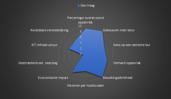
Of all provincial capitals, The Hague has the greatest precipitation risk in both 2018 and 2050. According to the precipitation index, The Hague has the largest number of buildings affected by extreme precipitation and suffers the greatest economic consequences in the event of pluvial flooding. The index also reveals the main risk – The Hague has a relatively large percentage of paved surface and a high percentage of urbanisation.
Interestingly, the expected economic growth (over 80%) contributes more to the increased risk in 2050 than the expected increase in precipitation (8%). However, this economic development also offers opportunities for taking advantage of it in order to reduce the precipitation risk.
Reducing risks
The precipitation index shows that, for a city like The Hague, there are clear mechanisms for reducing or more effectively managing precipitation risk. Increased areas of green could be introduced in order to reduce the paved surface. Equally, parts of the city could be renovated or increased in height in order to reduce the number of buildings affected by extreme precipitation.
Stimulating climate adaptation
Based on the precipitation index, cities can determine specific ambitions for different parameters and express these in practical goals. Bas Kolen: “Our aim is to continue to develop the method to include new parameters and improve the way in which the information and risks relate to each other. We believe that this approach, involving comparisons between cities, is an interesting way of encouraging climate adaptation in municipalities. We intend to publish an update of this list for all cities in the Netherlands once every few years.”

More information
The Dutch magazine Land+Water featured an article on this new precipitation index (Dutch, pdf).
The complete report of Tjerk Krijger can be downloaded here (Dutch)
Contact: <link tbm over-de-faculteit afdelingen values-technology-and-innovation people dsys dr-b-bas-kolen _blank>dr.ir. Bas Kolen, supervisor Tjerk Krijger, b.kolen@tudelft.nl
Science Information Officer Roy Meijer, r.e.t.meijer@tudelft.nl, +31 6 14015008
Photoheader: Tram in de regen bij Den Haag Centraal by Gerard Stolk
