Bachelor thesis – Renske Free
Detecting damage after earthquake using satellite data
When I was in the process of choosing a topic for my AES Bachelor Thesis an earthquake occurred on the Indonesian island of Lombok and it was disastrous. This made a big impression on me, because this geohazard took place in my country of birth. It has been a dream of mine to try and help countries after natural hazards by using the knowledge and skills learned during my AES bachelor. This was my opportunity! So I decided to research whether satellite data could be used to assess the damage of the earthquake on both the environment and the buildings and infrastructure.
Programming
In order to do so I had to find a way to accurately assess the damage on the Earth’s surface. During the bachelor I had learned to program and monitor the surface of the earth in different kinds of programs, such as QGIS and Matlab. But for this project I also had to learn the for me new language Java Script using a whole new program called Google Earth Engine. This was challenging for me, not only because it was all new, but also because of the time schedule. For a bachelor thesis of AES, you have only eight weeks to come up with a topic and do the research and finalize the report.

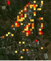
So, what did I do exactly? I wrote a Java Script code (figure 1) in which it would be possible to detect changes in satellite images of urban and rural areas before and after the earthquake. When this change was bigger than a certain ratio, that point was assumed to be damaged and colored in yellow, orange or red, indicating the severity of the damage (figure 2). All the damage which was found by using my code was compared to existing data of damage. This way, I could check whether the code was working and if it could be used in the future by emergency response groups. By them having more accurate knowledge of the damaged areas they could send the right aid to the right location quicker and more suited to the kind of damage in the area.
This made me realize that as Applied Earth Sciences engineers, you can contribute to solving real time and current problems worldwide!