Dynamic geo-fencing for metropolitan transportation management
Infrastructure shapes mobility. No major change in transport will be possible without the support of an adequate network and more intelligence in using it. (European Commission, 2011). Increasingly dense urbanisation requires a reconsideration of the design and use of public space. The new dynamic accessibility paradigm we are exploring can address this challenge of modern metropolitan areas maintaining, if not improving, quality of life standards like liveability, air quality, and noise—while preserving accessibility through well-managed transportation services.

We develop, study, and evaluate road network supply management approaches for areas that need to be ‘protected’ from traffic, for example due to an incident, traffic congestion or poor air quality. We use real-time variable perimeters to fence off the areas.
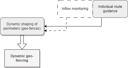
We first collect data on the key performance indicators and process that data by means of cleansing and data fusion techniques. Based on a convolution of heat maps, we draw up a two-dimensional map that shows the vulnerable areas. Through an optimization process, we draw the perimeters of the zone(s) to be protected. We then simulate the rerouting of the vehicles heading for these zone(s) to control and evaluate our approach.
Publications
Team
Nirvana Pecorari
dr. ir. Marco Rinaldi
prof. dr. Ludovic Leclercq
prof. dr. Serge Hoogendoorn